By Ken Battle
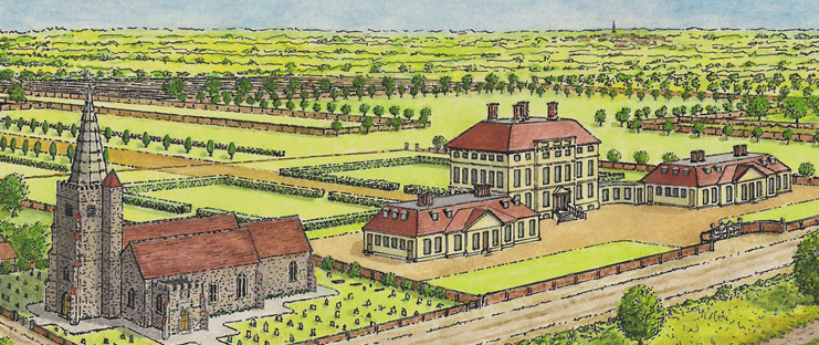
My recent ink and watercolour drawing gives an impression of a Sunbury riverside scene before 1750. It shows the old St. Mary’s Church (demolished 1750) and beside it Sunbury Park House built in 1712 for Sir Roger Hudson, Lord of the Manor, and at one time a Director of the South Sea Company. The Church has been drawn using details gleaned from an early undated watercolour now held by St. Mary’s.
It was flint built with nave, north/south aisles, chancel and castellated south porch. The castellated tower has a spire and stair turret topped with a pinnacle. The appearance of the Hudson House is known with some certainty as an engraving of its plan and elevation is included in Colen Campbell’s architectural work ‘Vitruvius Britannicus’ (1715-25). The House was built in the fashionable Palladian style and included two side pavilions set forward of the main house for staff and stabling. The landscape in the drawing includes a number of features shown on the Sunbury map of 1722 and the Rocque map of 1754.
The Rocque map shows a tree-lined avenue leading from the house and crossing the Park, together with substantial tree planting around the Park periphery. An interesting walled feature annotated ‘Foreland’ on the 1722 map, partly crosses the Park from the north. Although it had been truncated at both ends by 1722, in earlier times it almost certainly continued to the Thames via the land beside the House, and thus the Foreland can be seen as the genesis of the later Walled Garden.
Although not fully understood, this substantial Foreland (wider than the M3) was probably a busy farming highway linking the fields of Sunbury and Kempton with vital river transport. It is known that a Ferry was conveyed with the Manor in 1604, and this may have been situated opposite the Walled Garden entrance.
With acknowledgement to the Sunbury & Shepperton Local History Society who first published a monochrome version of this drawing in the SSLHS Journal for Autumn 2012.

